Applying NextGen Structure
Mike Johnson
Lynker, NOAA-AffiliateSource:
vignettes/04-applying-nextgen-model.Rmd
04-applying-nextgen-model.RmdNextGen
Once we have a network aggregated to a scale matching the desired hydrologic processes we need to turn it into something NextGen can use (modeling task)

Divergent Topology
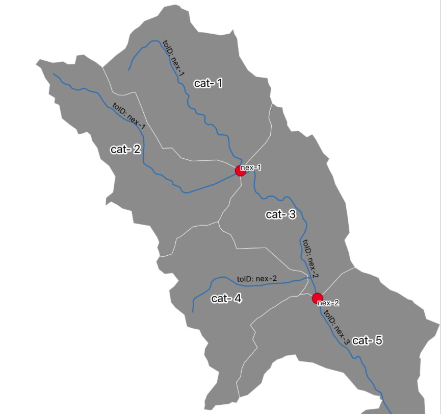
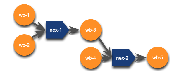
NextGen operates on a [flowpath --> nexus] vs
[flowpath --> flowpath] topology
This is due to the HY Features conceptual catchment that has 1 inflow draining to 1 outflow.
And example of this can be seen below:


Character based indentification
NextGen requires integer based identification, like described in the data model, prefixed with a character string defining what the feature is
Right now, the following prefixs are used to distinguish between types of model features.
| Parameter | Purpose | Elected Value |
|---|---|---|
| nexus_prefix | the maximum length flowpath desired in the output. | “nex-” |
| terminal_nexus_prefix | the minimum length of inter-confluence flowpath desired in the output. | “tnx-” |
| coastal_nexus_prefix | the minimum length of between-confluence flowpaths. | “cnx-” |
| internal_nexus_prefix | the maximum length flowpath desired in the output. | “inx-” |
| catchment_prefix | the minimum length of inter-confluence flowpath desired in the output. | “cat-” |
| waterbody_prefix | the minimum length of between-confluence flowpaths. | “wb-” |
The following function (1) identifies nexus locations, (2) moves them when needed and (3) applies the above schema to the features.
ngen = 'tutorial/nextgen.gpkg'

unlink(ngen)

ngen <- apply_nexus_topology("tutorial/aggregated.gpkg", export_gpkg = 'tutorial/nextgen.gpkg')
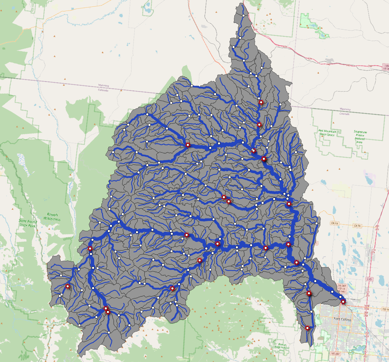
We can see the results of this by opening the hydrofabric and adding it to a map!
mapview::mapview(read_hydrofabric(ngen)) + read_sf(ngen, "nexus")Extending NWM attributes
The core utilities provide a series of flowpath, divide, and nexuses.
sf::st_layers(ngen)
#> Driver: GPKG
#> Available layers:
#>       layer_name geometry_type features fields             crs_name
#> 1      flowpaths   Line String      396     10 NAD83 / Conus Albers
#> 2        divides       Polygon      396      9 NAD83 / Conus Albers
#> 3          nexus         Point      173      4 NAD83 / Conus Albers
#> 4 hydrolocations            NA       42      3                 <NA>
#> 5        network            NA     1308     14                 <NA>
However, other information is needed to run some/all NextGen formulations. These include the following:
Flowpath Attributes
- Flowpath attributes are extracted from the a Routelink file
- The values are length averaged by the portion of length each makes up in the refactored/aggregated network
For example, if a 75m flowline has a roughness of 0.05 and a 25m flowline with a roughness of 0.2
(n = (.75 * .05) + (.25 * .2))
#> [1] 0.0875
Flowpaths attributes and lake parameters can be added by pointing to a set of NWM domain files like those found here
add_flowpath_attributes(ngen, source = "/Users/mjohnson/hydrofabric")
#> [1] "tutorial/nextgen.gpkg"
read_sf(ngen, "flowpath_attributes")
#> # A tibble: 396 × 12
#>    id     rl_Qi_m3s rl_MusX   rl_n  rl_So rl_ChSlp rl_BtmWdth_m rl_Kchan_mmhr
#>    <chr>      <dbl>   <dbl>  <dbl>  <dbl>    <dbl>        <dbl>         <dbl>
#>  1 wb-1           0     0.2 0.06   0.0197    0.517         3.91             0
#>  2 wb-10          0     0.2 0.0565 0.0481    0.420         9.14             0
#>  3 wb-100         0     0.2 0.06   0.0971    0.641         2.33             0
#>  4 wb-101         0     0.2 0.06   0.064     0.634         2.39             0
#>  5 wb-102         0     0.2 0.06   0.0726    0.628         2.45             0
#>  6 wb-103         0     0.2 0.06   0.0552    0.679         2.05             0
#>  7 wb-104         0     0.2 0.06   0.0397    0.656         2.33             0
#>  8 wb-105         0     0.2 0.06   0.0596    0.610         2.61             0
#>  9 wb-106         0     0.2 0.06   0.0453    0.584         3.01             0
#> 10 wb-108         0     0.2 0.06   0.114     0.722         1.79             0
#> # ℹ 386 more rows
#> # ℹ 4 more variables: rl_nCC <dbl>, rl_TopWdthCC_m <dbl>, rl_TopWdth_m <dbl>,
#> #   length_m <dbl>
Themeing
As an option, QGIS QML theming files can be added to a gpkg. Some
default themeing files come with hydrofabric and can be specified/added
with the append_styles utility on the desired
layer_names
append_style(ngen,layer_names = c("nexus", "hydrolocations", "flowpaths", "divides", "lakes"))In QGIS, double clicking the gpkg file will allow you to select which layers to load.
